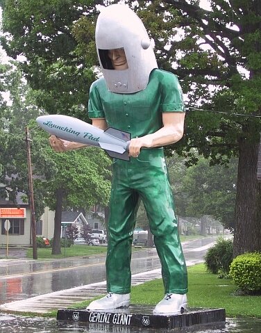
We backtracked north on IL 53 a bit to find the Gemini Giant at the Launching Pad Drive-In
at 810 E. Baltimore St., as 53 is known
there. The Giant is one of the "Muffler Men",
manufactured by International Fiberglass in the sixties and seventies.
There are lots of "Historic Route 66" signs in Illinois, but backtracking is harder because the
signs seem only to be posted in the westbound direction.
The Polka Dot is close enough to the Launching Pad in travel time that
you probably only want to get something to eat at one of them. If you stop to eat at every Route 66 Drive-In
and Diner you will gain a lot of weight!
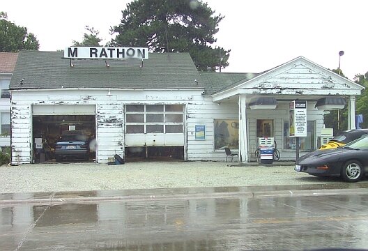
In Dwight, we found the Marathon Station at 417 W. Waupansie St. Leaving Dwight we picked up
Old Highway 66 and headed for Odell. We didn't get a shot of Feddersen's Pizza Garage at 309 S. Old Route 66
because of the rain but we will next time.
We did stop at Meramec (although we took no pictures there); the caverns were pretty but it is
definitely not a state park. The "Kate Smith" light show (manually operated by the
tour guide with noisy toggle switches) was the main tip-off.
All along the Route, we kept an eye out for the old telephone poles along the railroad
right of ways (like the one behind the Log Cabin). They were often a welcome signpost when
there were few other signs we were on the right road.
It was hard at first not to expect to get to a certain place each night, but after the first day or
two we settled into a nice routine: hit the road after breakfast, explore until dinner time and
stay wherever we wound up after dinner. For someone used to Cincinnati to Jacksonville in one day,
it was a welcome change of pace.
A large part of the fun is meeting the wonderful folks who call Route 66 their home. Everyone has
stories to tell and lots of helpful hints about what not to miss as you head west.
It's often hard to be sure you're on Route 66, but if you hit the towns in the right order and
go through on the business loops, you can't be far from where you want to be.
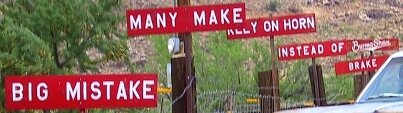
Along the Route in Illinois are a number of "restored" Burma Shave signs. Keep your eyes peeled for a sequence
of four or five small red signs with white lettering, about a hundred feet apart along the side of the road.
Typically found along rural stretches, their messages are usually good advice in humorous rhyme.
This set is courtesy the Hackberry General Store (below).
As you can see from their sign, Route 66 visitors are welcome here and everywhere along the Route.
Illinois has done a great job of maintaining their Route 66 heritage. West of Illinois it was more
hit and miss; some towns were very conscious of their place on the Route, while others seemed to
not even care...
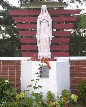
We left Springfield via the west frontage road, so that we wouldn't miss Our Lady of the Highway between
Waggoner and Raymond. Built and maintained by the owners of the neighboring house, it offers a nice
blessing for those on a road which wasn't always as quiet (or safe) as it is now.
It surprised me how pleasant it was to drive the rural two-lanes. It gave me a genuine and lasting dislike
for interstates, although I think the interstates are safer at night.
We elected to bypass St. Louis, taking the opportunity to go through Collinsville to see the
World's Largest Catsup Bottle (on IL 159).
Route 66 in Missouri is not nearly as well marked, although there are still some Historic Route 66 signs.
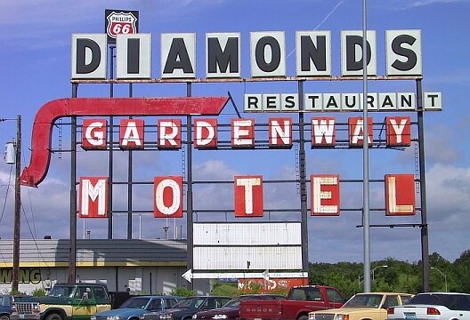
The Diamonds Restaurant and Motel in Gray Summit marks our first Missouri photo op, and was quickly followed by...
And it's along here that you'll find Meramec Caverns, in a lush green valley in Stanton, a few miles
down the hill on MO W.
Somehow we missed Route 66 Motors on MO KK in Saint James, and a little further on missed the turn to
Devil's Elbow. The latter is a left onto Teardrop Rd. from MO Z at the bottom of the hill just before
you cross the Big Piney River. We intend to not miss either on our next trip.
At Bennett Springs we met what seems to be a regional salad made with broccoli,
cauliflower, peas, celery, raisins and a creamy dressing that I don't recall the name of but really enjoyed.
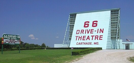
The 66 Drive-In in Carthage is another stop for our next trip,
when we plan to arrive at dusk instead of mid-morning.
The Historic Route 66 signs were pretty confusing in Webb City, but we managed to make it into...
In Kansas the Route
is known as KS 66 and is well-marked, and the Route 66 signs stenciled on the road surface
first make their appearance.
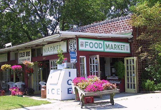
Eisler Brother's Market on the east side of Riverton has all manner of memorabilia in addition to the sorts of
things you expect at a roadside market.
It was a hot summer; the thermometer in the Prius went
over 100 degrees for the first time and did so every day thereafter until we got back to Missouri on
the return trip (except for two delightful days on the west coast).
From here we had lunch in Baxter Springs and continued on into...
The Twin Bridges (obviously not quite twins) cross the Verdigris River before you get to Catoosa.
OK 66 is known as the "free road", since the interstate it parallels is a toll road. For this reason, there
is far more traffic (including a fair number of trucks) along this stretch than along any other part of
Route 66.
In Chandler we found the Lincoln Motel on the right and had lunch at Grannie's Country Kitchen.
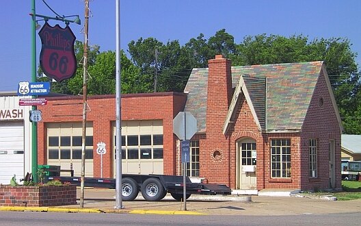
There is a restored Phillips 66 Station in Luther on the right.
We went through Yukon in the afternoon, and it is yet another stop that we want to make on our next trip:
the lighted Yukon Flour Mill sign is supposed to be quite a sight in the evening.
Route 66 between Clinton and Elk City is largely a matter of criss-crossing between the north and south
frontage roads of I-40.
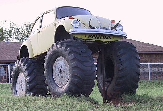
We ran into a bit of folk art west of Clinton which I couldn't pass up:
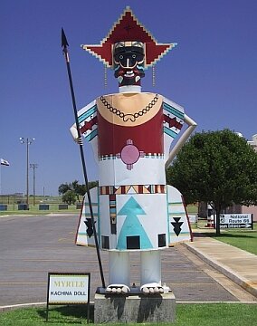
After lunch we went to visit
"Myrtle", the Kachina Doll outside the National Route 66 Museum, and toured the museum. Highlights included
a 1929 Stewart Truck that was actually an RV, a telephone booth just like the ones in the
Tri-County Truck Stop (above) and a lot of road history.
Heading west toward Texas we encountered a small series of road obstacles that illustrate how
little used Route 66 is: a bale of hay someone dropped (I assume accidentally) and several cows.
As we left Oklahoma we also left behind the stenciled Route 66 signs and most of the Historic Route 66 signs.
Except for specific areas, the Route seems more forgotten in the western states...
If you spend any time getting on and off I-40, be careful: the ramps merge directly into the frontage roads
and if you're not used to it it's a little scary at first. Of course there is so little traffic it's
not really much of a problem.
Amarillo was a nice exception to the lack of Route 66 signage in Texas: the Historic Route 66 signs
were plentiful and helpful.
A lot of guides suggest a side trip to Palo Duro Canyon. It is a beautiful place, although when we visited
(early one hot morning in July) the insects were so bad you couldn't get out of the car. But the
large spiders and roadrunners in the road made it a worthwhile trip, and the North Plains Museum in
Canyon is nice as well. If you like a beer with your meal or at the end of the day, beware: Canyon is dry.
We drove the old gravel road from Glenrio: miles from anything and 108 degrees (again) made me realize
that if we had car trouble we were going to die out there. Luckily we had been carrying lots of ice water
every day in a cooler in the back seat.
But we did get to see our first tumbleweed! Maximum speed was about 20 and we took
the first opportunity to get back on I-40 at exit 369 in Endee, NM. And then spent the next hour hearing gravel
bounce around our wheel wells as it slowly came out of our tire treads.
New Mexico signage is about like Missouri, so it's a little easier to know you're on the right track.
Albuquerque had especially plentiful signage: at several intersections, there were Historic Route 66 signs
pointing in all four directions!
We took the pre-1937 alignment which follows what is now US 84 to Romeoville (spending the night
in Las Vegas) and on to Santa Fe. A side trip to Bandelier National Monument (where you have to
climb to the ceremonial cave), then south on NM 313 through Albuquerque to Los Lunas. Forest fires north of Santa Fe
were eerily visible from the road to Bandelier, and high winds and dust reduced the visibility to under
100 feet in places along 313.
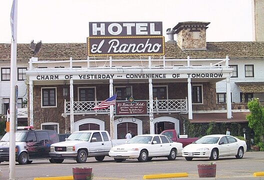
Joining up on I-40 again at exit 126 and then hopscotching back and forth along NM 122 and 124 and I-40
we finally arrived at Gallup, home of the Hotel El Rancho.
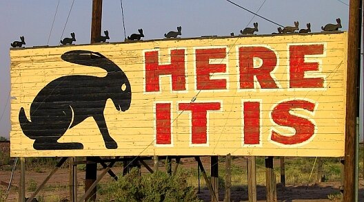
The Jack Rabbit Trading Post is on one of the south frontage road segments at I-40 exit 269 and is worth
the stop. But don't get there too early, as we did.
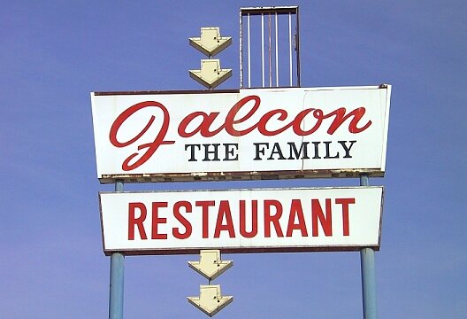
We had a great breakfast at the Falcon Restaurant in Winslow, including the best home fries we ever tasted.
A side trip south at exit 233 leads you to the Meteor Crater. It's worth seeing, but is a privately owned and
operated attraction so bring some bucks.
Flagstaff looked like a lovely town. It was monsoon season: each afternoon a terrific wind blows up,
followed by a shower. Then things settle down and it stays cloudy until the next afternoon. Today's storm
was beautiful and followed us out of Flagstaff through lovely pine forests.
The storm caught up with us just as we were about to lunch at Delgadillo's Snow Cap in Seligman (which has to be seen
to be believed). First dust, then rain was blowing horizontally across the road and we opted instead
to eat inside at the Copper Cart (and got a very good burger). But we do feel like we owe Delgadillo a stop
on our next trip.
You can see the evolution of transportation
on a trip like this: first there were trails, then railroads. The roads were built along the railroads and
then the interstates were built along the roads: each mode provided the infrastructure for its
own replacement.
Grand Canyon Caverns provides a photo op along what is otherwise a very quiet portion of the trip.
The drive to Oatman is unforgetable: winding and narrow, and the maximum safe speed is usually
in the 20's. There are a lot of switchbacks and no guard rails: if your passenger is afraid of heights they
might want to cower behind the driver's seat.
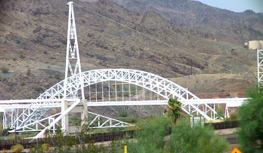
There is another Rainbow Bridge in sight as you cross over into Needles, California. Crossing over the
Colorado River, it now carries a natural gas pipeline.
Needles takes its name from the aspect of the nearby "mountains".
Heat has been a problem out west all summer. Today's high was 111, although on the return trip we hit 118
along Lake Mead in Nevada, and with a 30 mph wind blowing off the lake. Don't let anyone tell you about
the "dry heat"; it's still awful. Couldn't see well to focus the camera because my eyes dried out as
soon as I got out of the car.
Leaving Needles we began the worst part of the entire trip: north into Goffs and then south onto the
National Old Trails Highway. It's no wonder that this part of California often is the hottest place on the map:
it's all desert. Ugly and boring, with occasional exceptions (including rock signs placed along the road
by earlier travelers).
You might
see the occasional Joshua Tree, but mostly it's long stretches of straight, rough roadbed and the
maximum comfortable speed is in the 40s.
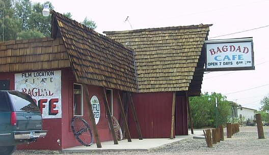
The Bagdad Cafe in the picture is actually in Newberry Springs.
There were some very cool murals on the sides of buildings in Barstow and in fact all along the Route.
I would like to suggest that one of you do a photo trip of the Route to document them!
At 16849 D St. in Victorville is the best Route 66 museum and shop on the Route (to my taste, at
any rate).
And shortly after Victorville we did the unthinkable: we departed from Route 66.
As you near San Bernadino and then Los Angeles, roads get very crowded and after ten days of mostly
lonely two lanes, I wasn't ready to face it. Or so I thought... So I looked at the map and lucked
into one of the nicest drives I've ever had. Leaving I-15 at Cajon Summit we took CA 138 west to
CA 2 and drove through Angeles National Forest. 66 miles of nicely banked, winding roads with plenty of
places to pull over, beautiful vistas, nothing straight longer than 1/4 mile and a top altitude of about 7500 feet.
Top speed was usually in the low 40s and it was exhilarating! Which is probably the only reason I survived
what happened next.
We had thought we would stay on the outskirts of L.A. and see the western end of Route 66 the next morning.
But upon exiting Angeles we found ourselves having to make quick choices with little signage and no motels in sight.
And so we found ourselves heading west into L.A. at 6 PM on a Friday evening in the midst of more cars
than I had ever seen in one place. And the amazing thing was, it worked! Most of the drivers were
courteous (or at least forgiving of the rube from Ohio). Every time my wife would locate a motel in the AAA
book I would tell her that we just passed that exit. But eventually we found a room on Sepulveda Blvd. and
ate our anniversary dinner in a Denny's. So much for avoiding the big cities...
We enjoyed the trip thoroughly (OK, maybe not the National Old Trails Highway, but the rest was great),
but we were not quite ready to do it all again, backwards. So we drove up the Pacific Coast Highway
(every bit as fun as driving in Angeles National Forest) to Monterey. Then we cut east and drove through
Yosemite, Death Valley, Zion, Bryce Canyon, Canyonlands and Arches National Parks. For my money, you could just
save time and make the entire state of Utah a national park; it's that beautiful. And then we decided we
were ready to be home, and reluctantly spent three days on the interstate heading east.
As you can see, we averaged about 250 miles a day on the way out, and that seemed like a reasonable pace. Between L. A. and Moab
we averaged almost 400 miles a day, and for the last 3 days we averaged about 525 miles a day. Of course it depends on where home is
for you, and whether or not you want to take some time to see the big cities. As they say, your mileage may vary...
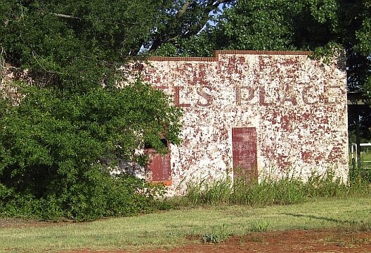
But if you get the chance to explore Route 66, do it! It can only thrive if we travel it, and things change (as of this writing,
Ernie's Pig Hip is no more; it burned to the ground in 2007).
©2009, Kenneth R. Koehler. All Rights Reserved.
Illinois
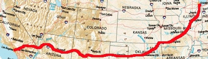
 We are not big city people, so we elected to bypass Chicago and pick up 66 in Wilmington, Illinois,
where it now goes by the name of Illinois 53. Starting from Cincinnati, we took I-74 to Indianapolis,
I-465 around Indy to I-65 and then US 52 from Lebanon, Indiana to Kankakee, Illinois. From there we took
IL 102 into Wilmington.
We are not big city people, so we elected to bypass Chicago and pick up 66 in Wilmington, Illinois,
where it now goes by the name of Illinois 53. Starting from Cincinnati, we took I-74 to Indianapolis,
I-465 around Indy to I-65 and then US 52 from Lebanon, Indiana to Kankakee, Illinois. From there we took
IL 102 into Wilmington.
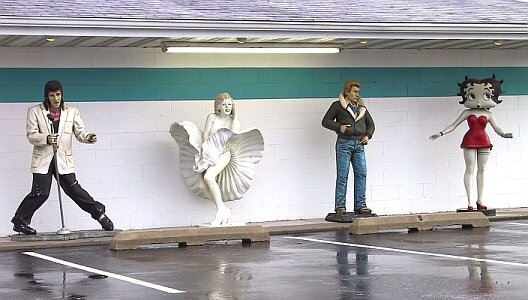 Continuing on IL 53 to Braidwood, our next photo op was the Polka Dot Drive-In
at 222 N. Front St. There is another set of figures on the other side.
Continuing on IL 53 to Braidwood, our next photo op was the Polka Dot Drive-In
at 222 N. Front St. There is another set of figures on the other side.
 As we left Gardner, we picked up the frontage road on the southeast side of I-55 and continued
on to Dwight. Traveling the frontage roads is a hoot, because at times you're making faster
progress than all those fools on the interstate!
As we left Gardner, we picked up the frontage road on the southeast side of I-55 and continued
on to Dwight. Traveling the frontage roads is a hoot, because at times you're making faster
progress than all those fools on the interstate!
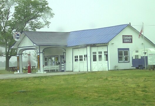 At 400 S. West St. in Odell, there is a restored Standard Sinclair Gas Station which is very cool.
It features a glass visible register type pump, in which the amount of gas you wanted to
purchase was pumped into the glass tank, and gravity fed it into your car.
At 400 S. West St. in Odell, there is a restored Standard Sinclair Gas Station which is very cool.
It features a glass visible register type pump, in which the amount of gas you wanted to
purchase was pumped into the glass tank, and gravity fed it into your car.
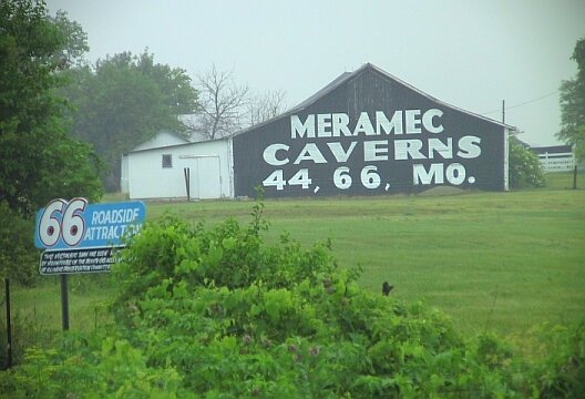 Between Cayuga and Pontiac there is a barn on the west side of the road which is
painted with a Meramec Caverns Sign.
Between Cayuga and Pontiac there is a barn on the west side of the road which is
painted with a Meramec Caverns Sign.
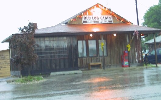 Just north of Pontiac at 18700 Old Route 66 is the Old Log Cabin Restaurant, which was picked up and turned around
when the alignment was shifted. They're still serving a fine breakfast and Route 66 memorabilia.
Just north of Pontiac at 18700 Old Route 66 is the Old Log Cabin Restaurant, which was picked up and turned around
when the alignment was shifted. They're still serving a fine breakfast and Route 66 memorabilia.
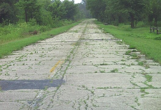 North of Lexington on Old Route 66 is Memory Lane, an abandoned stretch of an old alignment which is
now a walking trail. Once a year it is opened to vehicle traffic; we missed the official day
(which was the previous weekend) but it was still open so we had it all to ourselves.
North of Lexington on Old Route 66 is Memory Lane, an abandoned stretch of an old alignment which is
now a walking trail. Once a year it is opened to vehicle traffic; we missed the official day
(which was the previous weekend) but it was still open so we had it all to ourselves.
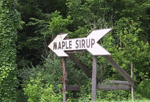 Leaving Bloomington on Old Route 66 we continued on to Funk's Grove. "Sirup" is apparently the
original spelling, and the sirup we purchased from Linda Funk was the real thing. Also bought
my treasured Route 66 key-chain there, and got an update on Ernie's Pig Hip (below).
Leaving Bloomington on Old Route 66 we continued on to Funk's Grove. "Sirup" is apparently the
original spelling, and the sirup we purchased from Linda Funk was the real thing. Also bought
my treasured Route 66 key-chain there, and got an update on Ernie's Pig Hip (below).
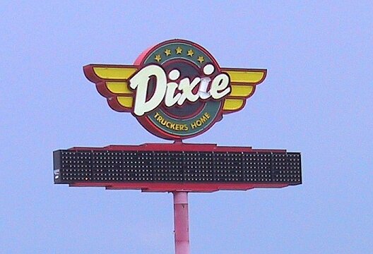 We arrived at the Dixie Trucker's Home in McLean in the midst of a downpour - visibility was about
100 feet - and got drenched running in for lunch. But the food was great and the cobbler was
even better. The buffet is highly recommended, especially if you are very hungry, and the Hall of Fame
of the Route 66 Association of Illinois was a nice place to wait out the rain. The Hall of Fame is reportedly to
be moved to the new Route 66 museum in Pontiac.
We arrived at the Dixie Trucker's Home in McLean in the midst of a downpour - visibility was about
100 feet - and got drenched running in for lunch. But the food was great and the cobbler was
even better. The buffet is highly recommended, especially if you are very hungry, and the Hall of Fame
of the Route 66 Association of Illinois was a nice place to wait out the rain. The Hall of Fame is reportedly to
be moved to the new Route 66 museum in Pontiac.
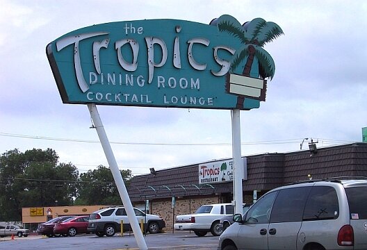 Continued on to Atlanta and then on the frontage roads again to Lincoln. The Tropics Dining Room
is on the I-55 Business Loop but as happened all too often we were still too full from lunch
to stop.
Continued on to Atlanta and then on the frontage roads again to Lincoln. The Tropics Dining Room
is on the I-55 Business Loop but as happened all too often we were still too full from lunch
to stop.
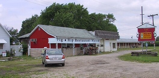 The Pig Hip Restaurant Museum is at 101 W. Oak St. in Broadwell. We were the only car there, and
the museum was open but empty so we nosed around for a while until Ernie noticed our car and
stopped in for a chat. He told us not to miss our next photo op in Springfield at...
The Pig Hip Restaurant Museum is at 101 W. Oak St. in Broadwell. We were the only car there, and
the museum was open but empty so we nosed around for a while until Ernie noticed our car and
stopped in for a chat. He told us not to miss our next photo op in Springfield at...
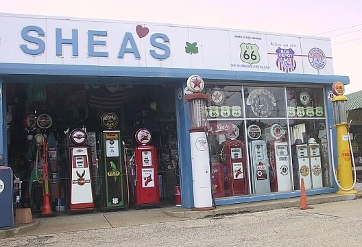 Shea's Marathon - now a sort of museum - at 2075 Peoria Rd. He has a fascinating collection of
gas station and automobile memorabilia and a collection of signs that are a hoot!
Shea's Marathon - now a sort of museum - at 2075 Peoria Rd. He has a fascinating collection of
gas station and automobile memorabilia and a collection of signs that are a hoot!
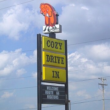 The Cozy Dog Drive-In, at 2935 S. 6th St. in Springfield, is reputedly the birthplace of the corn dog, and has
one of my wife's favorite signs of all we saw on the trip.
The Cozy Dog Drive-In, at 2935 S. 6th St. in Springfield, is reputedly the birthplace of the corn dog, and has
one of my wife's favorite signs of all we saw on the trip.
 If you have time in Springfield, be sure to tour the Frank Lloyd Wright Dana-Thomas House at
301 E. Lawrence Ave. What amazed us was how everything in the house was designed by him,
from the exterior to the smallest furnishings. Just spectacular!
If you have time in Springfield, be sure to tour the Frank Lloyd Wright Dana-Thomas House at
301 E. Lawrence Ave. What amazed us was how everything in the house was designed by him,
from the exterior to the smallest furnishings. Just spectacular!
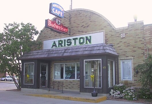 Dinner that evening was at the Ariston Restaurant at 413 N. Sherman St. The food was great; our only mistake
was buying only one Ariston/Route 66 souvenir glass. Between me, my wife and our son, it is one of our favorite
glasses (nice size, weight and shape, especially for a beer), and we need to go back some day to get two more.
Dinner that evening was at the Ariston Restaurant at 413 N. Sherman St. The food was great; our only mistake
was buying only one Ariston/Route 66 souvenir glass. Between me, my wife and our son, it is one of our favorite
glasses (nice size, weight and shape, especially for a beer), and we need to go back some day to get two more.
Missouri
 We then took I-64 to I-270 around to Manchester Road, where we picked up Route 66,
now known (except around Grover) as MO 100, once more.
We then took I-64 to I-270 around to Manchester Road, where we picked up Route 66,
now known (except around Grover) as MO 100, once more.
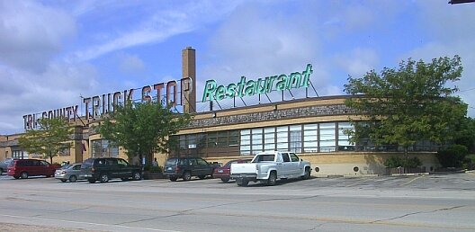 The Tri-County Truck Stop on MO AT in Villa Ridge; it has a wonderful old telephone booth. From here,
it's a lot of I-44 service roads and county roads, so it's very important to have
complete directions.
There is a winding stretch of nicely banked road in this vicinity that is pure pleasure to drive,
but it will really make you nostalgic for the old convertible.
The Tri-County Truck Stop on MO AT in Villa Ridge; it has a wonderful old telephone booth. From here,
it's a lot of I-44 service roads and county roads, so it's very important to have
complete directions.
There is a winding stretch of nicely banked road in this vicinity that is pure pleasure to drive,
but it will really make you nostalgic for the old convertible.
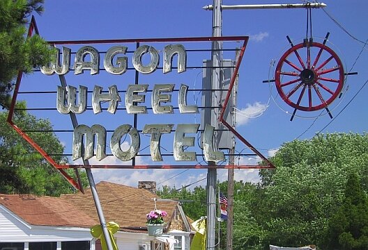 In Cuba you'll find the Wagon Wheel Motel. Unfortunately we arrived mid-day, and wanted to get a little
further before stopping. But the next Route 66 trip we make, we intend to make sure we get to Cuba
in time to spend the night there.
In Cuba you'll find the Wagon Wheel Motel. Unfortunately we arrived mid-day, and wanted to get a little
further before stopping. But the next Route 66 trip we make, we intend to make sure we get to Cuba
in time to spend the night there.
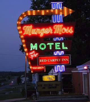 At 1336 E. Route 66 (or 236 E. Seminole, as it used to be addressed) in Lebanon, you'll find the Munger Moss Motel.
We stayed in the Route 66 room and loved it, but Ramona is also doing state-themed rooms and has wonderful
stories about the history of the motel and the Route 66 club visitors she has had from all over the
world. She also has recommendations for good food, such as the Bennett Springs State Park Dining Lodge (where
we had cherry pie to die for) and breakfast at Fay's Diner, where Fay recooked my wife's eggs because she
(Fay) didn't like how they turned out!
At 1336 E. Route 66 (or 236 E. Seminole, as it used to be addressed) in Lebanon, you'll find the Munger Moss Motel.
We stayed in the Route 66 room and loved it, but Ramona is also doing state-themed rooms and has wonderful
stories about the history of the motel and the Route 66 club visitors she has had from all over the
world. She also has recommendations for good food, such as the Bennett Springs State Park Dining Lodge (where
we had cherry pie to die for) and breakfast at Fay's Diner, where Fay recooked my wife's eggs because she
(Fay) didn't like how they turned out!
 In Springfield we passed a barbecue diner on Glenstone Avenue south of St. Louis St. (and therefore not really
on Route 66) which put out some divine smells but once again, we were not hungry enough to eat.
In Springfield we passed a barbecue diner on Glenstone Avenue south of St. Louis St. (and therefore not really
on Route 66) which put out some divine smells but once again, we were not hungry enough to eat.
Kansas
 ... where the chat fields in Galena give the meaning to it's nickname, "Hell's Half Acre".
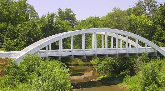 On the way into town keep an eye out for road to the March Rainbow Bridge, the last of its kind on the Route,
on an old alignment west of the main road. It had been freshly painted and can be driven one-way, although
the only traffic consists of Route 66 junkies.
On the way into town keep an eye out for road to the March Rainbow Bridge, the last of its kind on the Route,
on an old alignment west of the main road. It had been freshly painted and can be driven one-way, although
the only traffic consists of Route 66 junkies.
Oklahoma
 In eastern Oklahoma, the Route is clearly labeled OK 66. Four miles east of 66 on OK 28 is
Ed Galloway's Totem Pole Park, which is highly recommended.
In eastern Oklahoma, the Route is clearly labeled OK 66. Four miles east of 66 on OK 28 is
Ed Galloway's Totem Pole Park, which is highly recommended.
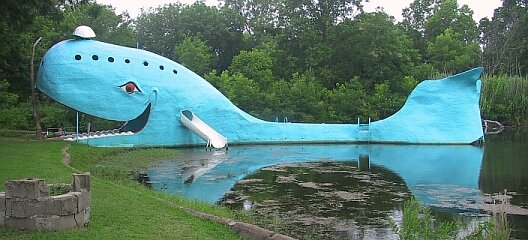 The Blue Whale in Catoosa is located on Old Highway 66. It is closed as a swimming or fishing pond but
you can still get close enough to get some good pictures and imagine what it was like with kids all
around. It had a fairly fresh coat of paint and looked great.
The Blue Whale in Catoosa is located on Old Highway 66. It is closed as a swimming or fishing pond but
you can still get close enough to get some good pictures and imagine what it was like with kids all
around. It had a fairly fresh coat of paint and looked great.
 We exited Tulsa on Old Sapulpa Rd. and weren't sure for a while if we had done the right thing, but eventually
picked up OK 66 again. There are a couple of loops of an old alignment beyond Kellyville, but beware:
they don't always return directly to OK 66. If you find yourself on OK 48, go south...
We exited Tulsa on Old Sapulpa Rd. and weren't sure for a while if we had done the right thing, but eventually
picked up OK 66 again. There are a couple of loops of an old alignment beyond Kellyville, but beware:
they don't always return directly to OK 66. If you find yourself on OK 48, go south...
 The Historic Route 66 signs are becoming more and more scarce, and we are starting to see flattened
armadillos on the side of the road: sure signs we are leaving the midwest.
The Historic Route 66 signs are becoming more and more scarce, and we are starting to see flattened
armadillos on the side of the road: sure signs we are leaving the midwest.
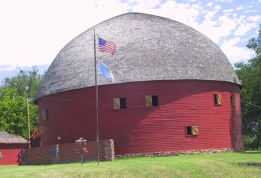 The round barn in Arcadia has a fine museum and gift shop on the first floor, with a very informative gentleman
attending, and the second floor can be rented for occasions. But the real star is the second floor ceiling,
which resembles nothing so much as a huge woven basket. You can also pick up a lot of literature on Route
66 in Oklahoma, which will help you find all the interesting stuff as you motor west.
The round barn in Arcadia has a fine museum and gift shop on the first floor, with a very informative gentleman
attending, and the second floor can be rented for occasions. But the real star is the second floor ceiling,
which resembles nothing so much as a huge woven basket. You can also pick up a lot of literature on Route
66 in Oklahoma, which will help you find all the interesting stuff as you motor west.
 My wife is a quilter, and we stopped at a quilt shop in each state we passed through. Finding our target
shop in Oklahoma City was tricky, and we saw quite a lot of town. At one point we dead-ended at Lake
Hefner, and in the 108 degree summer's heat it looked very inviting. But it was not to be, because we
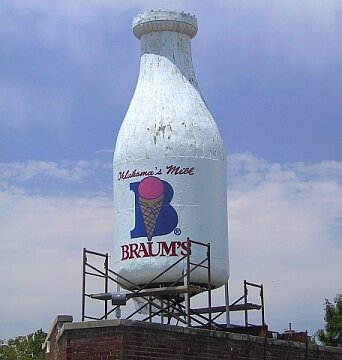
still had to find the Braum's Dairy Bottle on 25th St. and continue west.
My wife is a quilter, and we stopped at a quilt shop in each state we passed through. Finding our target
shop in Oklahoma City was tricky, and we saw quite a lot of town. At one point we dead-ended at Lake
Hefner, and in the 108 degree summer's heat it looked very inviting. But it was not to be, because we
still had to find the Braum's Dairy Bottle on 25th St. and continue west.
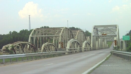
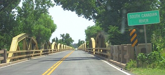 Between Fort Reno and Hilton Junction is the South Canadian River Bridge. It has 38 trusses and is nearly
4000 ft. long; the picture just begins to hint at the fact that this bridge seems to go on forever. It
was a bit difficult to find, but I'm not sure how I missed it at first: it's right on US 281.
Between Fort Reno and Hilton Junction is the South Canadian River Bridge. It has 38 trusses and is nearly
4000 ft. long; the picture just begins to hint at the fact that this bridge seems to go on forever. It
was a bit difficult to find, but I'm not sure how I missed it at first: it's right on US 281.
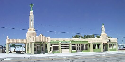
 The Oklahoma Route 66 Museum is at 2229 W. Gary Blvd. in Clinton, and across the street is the Trade Winds
Courtyard Inn, where Elvis once stayed in his younger days. The room he stayed in has been spiffed up
and rents for a hefty sum but it was already taken when we got there. Dinner at Adelina's is recommended
for those who like Mexican food.
The Oklahoma Route 66 Museum is at 2229 W. Gary Blvd. in Clinton, and across the street is the Trade Winds
Courtyard Inn, where Elvis once stayed in his younger days. The room he stayed in has been spiffed up
and rents for a hefty sum but it was already taken when we got there. Dinner at Adelina's is recommended
for those who like Mexican food.
 Kobel's Place is located in Foss, which is now a ghost town. It was one of the older roadside
attractions we had on our list and it doesn't look easy to find; I was surprised how quickly
I recognized it from the pictures I'd seen.
Kobel's Place is located in Foss, which is now a ghost town. It was one of the older roadside
attractions we had on our list and it doesn't look easy to find; I was surprised how quickly
I recognized it from the pictures I'd seen.
 Lunch at the Flamingo in Elk City is highly recommended: the closest thing to Grandma's cooking I've
tasted in a long time. And very reasonable.
Lunch at the Flamingo in Elk City is highly recommended: the closest thing to Grandma's cooking I've
tasted in a long time. And very reasonable.
Texas
 The U-Drop-Inn in Shamrock, Texas was freshly restored but not yet open, so we hope to visit it
again the next time on the Route.
The U-Drop-Inn in Shamrock, Texas was freshly restored but not yet open, so we hope to visit it
again the next time on the Route.
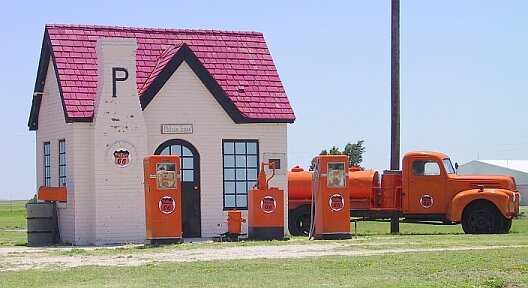 There is a restored Phillips 66 Station in McLean which makes a nice photo op but it was a little too
hot to spend much time looking around.
There is a restored Phillips 66 Station in McLean which makes a nice photo op but it was a little too
hot to spend much time looking around.
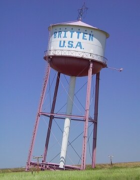 The "Leaning Water Tower of Britten" is actually in Groom. You may recognize it from the animations
seen between visits on the television show Rare
Visions and Roadside Revelations. Catch it if the idea of roadside icons at all intrigues you.
The "Leaning Water Tower of Britten" is actually in Groom. You may recognize it from the animations
seen between visits on the television show Rare
Visions and Roadside Revelations. Catch it if the idea of roadside icons at all intrigues you.
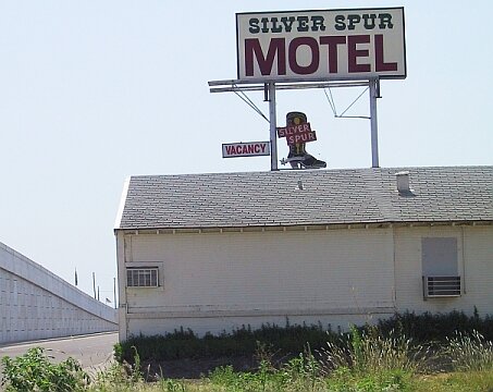 Coming into East Amarillo we see the Silver Spur Motel:
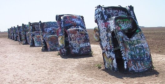 On the southern side of I-40, west of the Hope Rd. intersection, you will find
Stanley Marsh 3's Cadillac Ranch: 10 Cadillacs (1948 to 1964 models) buried nose down in concrete
at the precise angle of the great pyramids, and covered in graffiti. There are paint cans (and garbage bags)
at the gate if you feel inclined to add to the art.
On the southern side of I-40, west of the Hope Rd. intersection, you will find
Stanley Marsh 3's Cadillac Ranch: 10 Cadillacs (1948 to 1964 models) buried nose down in concrete
at the precise angle of the great pyramids, and covered in graffiti. There are paint cans (and garbage bags)
at the gate if you feel inclined to add to the art.
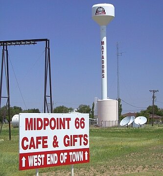 Here's the Midpoint Water Tower in Adrian. Lunch at the Midpoint Cafe was good (good burger and great pie) and
the gift shop was worth a browse.
Here's the Midpoint Water Tower in Adrian. Lunch at the Midpoint Cafe was good (good burger and great pie) and
the gift shop was worth a browse.
New Mexico
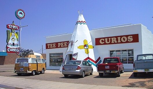 Our first stop in New Mexico was Tee Pee Curios in Tucumcari. It's obvious when you get to New Mexico
that about every other person you meet is an artist, and we had a nice chat with the folks in the
Tee Pee.
Our first stop in New Mexico was Tee Pee Curios in Tucumcari. It's obvious when you get to New Mexico
that about every other person you meet is an artist, and we had a nice chat with the folks in the
Tee Pee.
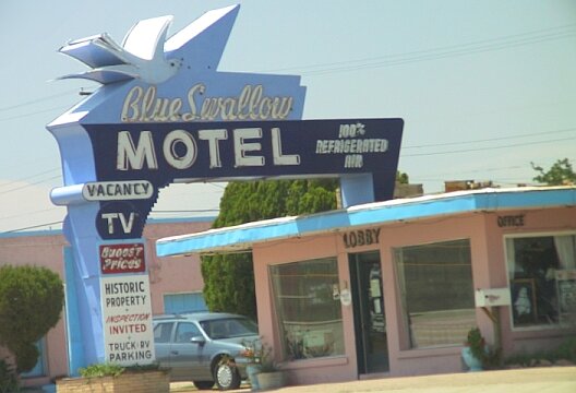 The Blue Swallow Motel is across the street from the Tee Pee and was also in the process of renovation,
so we'll have to wait until our next trip to try out their "100% Refrigerated Air" (no swamp coolers
here!). Each unit in the Blue Swallow features an attached garage.
The Blue Swallow Motel is across the street from the Tee Pee and was also in the process of renovation,
so we'll have to wait until our next trip to try out their "100% Refrigerated Air" (no swamp coolers
here!). Each unit in the Blue Swallow features an attached garage.
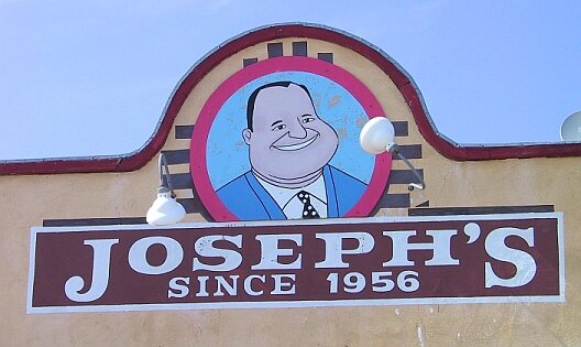 Had a snack and a shake at Joseph's Bar and Grill in Santa Rosa, with some very good (and very hot) salsa.
 We left Los Lunas on NM 6, which was perhaps the most beautiful part of the entire trip: 25 miles of
beautiful rock and mesas in the Laguna Reservation. This must have been where they got the nickname
for New Mexico: Land of Enchantment.
The only bad thing was the smoke from forest fires in the south which made photography difficult.
We left Los Lunas on NM 6, which was perhaps the most beautiful part of the entire trip: 25 miles of
beautiful rock and mesas in the Laguna Reservation. This must have been where they got the nickname
for New Mexico: Land of Enchantment.
The only bad thing was the smoke from forest fires in the south which made photography difficult.
Arizona
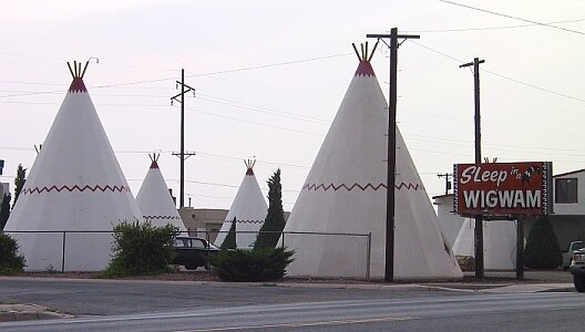 After a side trip through the Painted Desert and Petrified Forest National Park, we arrived in Holbrook,
ready for our stay at Wigwam Village. But first we visited the Pow Wow Trading Post, where we saw
the world's largest piece of carved turquoise. It features 17 scenes from the old west and took
three years to complete.
After a side trip through the Painted Desert and Petrified Forest National Park, we arrived in Holbrook,
ready for our stay at Wigwam Village. But first we visited the Pow Wow Trading Post, where we saw
the world's largest piece of carved turquoise. It features 17 scenes from the old west and took
three years to complete.
 In New Mexico and Arizona, Route 66 has not only been superceded by the interstate, it has been
covered by it in many places. So there are a few stretches were interstate travel is essentially your
only option if you want to stay anywhere near the original route.
In New Mexico and Arizona, Route 66 has not only been superceded by the interstate, it has been
covered by it in many places. So there are a few stretches were interstate travel is essentially your
only option if you want to stay anywhere near the original route.
 Once again, complete directions are a must if you want
to see as much of the original route as possible. But take every opportunity to get off the interstate; some
of the two lane bits are beautiful drives and some even take you out of sight of the highway.
Once again, complete directions are a must if you want
to see as much of the original route as possible. But take every opportunity to get off the interstate; some
of the two lane bits are beautiful drives and some even take you out of sight of the highway.
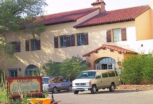 Winslow is also home to La Posada Hotel (an original Harvey House at 303 E. 2nd St.)
and the corner mentioned in the Eagles' song "Take It
Easy" (at 2nd and Kinsley). The former looked like a wonderful place to stay on our next trip, and
there are several nice shops near the latter.
Winslow is also home to La Posada Hotel (an original Harvey House at 303 E. 2nd St.)
and the corner mentioned in the Eagles' song "Take It
Easy" (at 2nd and Kinsley). The former looked like a wonderful place to stay on our next trip, and
there are several nice shops near the latter.
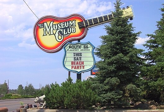 The Museum Club in Flagstaff at 3404 E. Route 66 is yet another attraction left for our next trip due to
timing problems: night clubs
aren't generally open in the mornings. This leads me to think that our next trip may have to be more structured...
The Museum Club in Flagstaff at 3404 E. Route 66 is yet another attraction left for our next trip due to
timing problems: night clubs
aren't generally open in the mornings. This leads me to think that our next trip may have to be more structured...
 The Route 66 road stencils and Burma Shave signs have reappeared to some extent. And you get to get off the
interstate at exit 139 for perhaps the nicest stretch of the whole trip: Seligman to Kingman.
The Route 66 road stencils and Burma Shave signs have reappeared to some extent. And you get to get off the
interstate at exit 139 for perhaps the nicest stretch of the whole trip: Seligman to Kingman.
 This stretch is labeled AZ 66, and it has the most "authentic" feel of any part of the Route, primarily
because it is the longest segment away from the interstate. It's a beautiful drive.
This stretch is labeled AZ 66, and it has the most "authentic" feel of any part of the Route, primarily
because it is the longest segment away from the interstate. It's a beautiful drive.
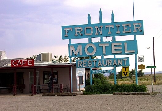 We found the Frontier Motel and Cafe in Truxton looking very sleepy. Drove through the worst wind I've
ever driven in (even counting two days before on NM 313). Tumbleweeds are very plentiful, giving the
midwesterner a real feeling of being in the old west.
We found the Frontier Motel and Cafe in Truxton looking very sleepy. Drove through the worst wind I've
ever driven in (even counting two days before on NM 313). Tumbleweeds are very plentiful, giving the
midwesterner a real feeling of being in the old west.
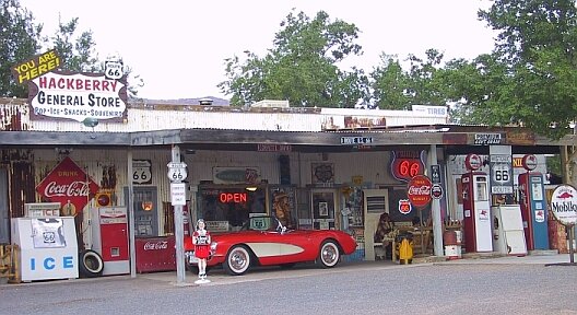 The Hackberry General Store in (of course) Hackberry is a great place to stop for a cool drink (have a
Route Beer) and browse the memorabilia and souvenirs. The Route 66 Visitor's Center here was established
by Bob Waldmire, who has created a nifty set of pen and ink post cards which are very informative
and have guided our search for roadside culture along much of the trip.
The Hackberry General Store in (of course) Hackberry is a great place to stop for a cool drink (have a
Route Beer) and browse the memorabilia and souvenirs. The Route 66 Visitor's Center here was established
by Bob Waldmire, who has created a nifty set of pen and ink post cards which are very informative
and have guided our search for roadside culture along much of the trip.
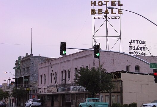 The Hotel Beale in Kingman is an old Route 66 icon, but we stayed in the Quality Inn which features a
lot of memorabilia. Also recommended is Capello's (if you like Italian) which is just off the Route;
ask the motel clerk for directions.
The Hotel Beale in Kingman is an old Route 66 icon, but we stayed in the Quality Inn which features a
lot of memorabilia. Also recommended is Capello's (if you like Italian) which is just off the Route;
ask the motel clerk for directions.
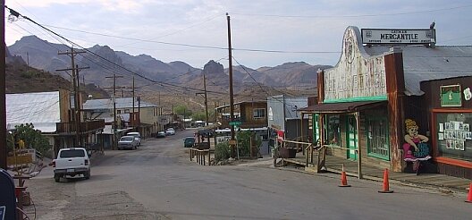 We had planned to stay at the Oatman Hotel, but when we phoned ahead we were warned against it: more
108 temperatures and no air conditioning. I freely admit I've become very spoiled... And for some
reason the wild burros were not to be found (although it was very early in the morning: perhaps they were still
asleep).
We had planned to stay at the Oatman Hotel, but when we phoned ahead we were warned against it: more
108 temperatures and no air conditioning. I freely admit I've become very spoiled... And for some
reason the wild burros were not to be found (although it was very early in the morning: perhaps they were still
asleep).
California
 The drive from Oatman to Topock was very nice, winding road with none of the thrills of the Kingman-to-Oatman
stretch but very fun to drive, and there is even room to stop for a photo now and then.
The drive from Oatman to Topock was very nice, winding road with none of the thrills of the Kingman-to-Oatman
stretch but very fun to drive, and there is even room to stop for a photo now and then.
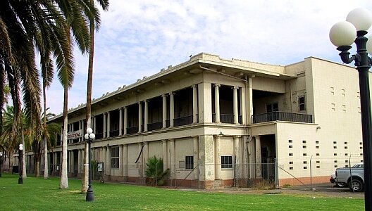 The El Garces Hotel in Needles (another Harvey House) is in the process of restoration
(as indicated by the sign) but is far from finished.
The El Garces Hotel in Needles (another Harvey House) is in the process of restoration
(as indicated by the sign) but is far from finished.
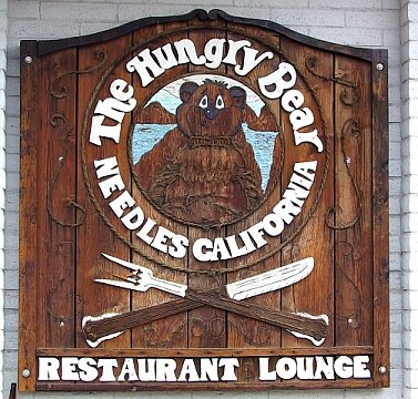 But getting back to Needles, the Hungry Bear Restaurant is open on the west end of town, and serving great food.
It was still early but we ordered strawberry milkshakes. When the waitress found out she had no
strawberry syrup, she cut up fresh ones and made us the best shakes we had ever tasted.
But getting back to Needles, the Hungry Bear Restaurant is open on the west end of town, and serving great food.
It was still early but we ordered strawberry milkshakes. When the waitress found out she had no
strawberry syrup, she cut up fresh ones and made us the best shakes we had ever tasted.
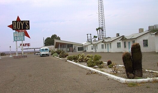 Roy's Motel and Cafe in Amboy is not open for travelers; apparently its primary usage is as a movie set.
But Amboy is home to a volcanic crater of note that you can see from the highway.
Roy's Motel and Cafe in Amboy is not open for travelers; apparently its primary usage is as a movie set.
But Amboy is home to a volcanic crater of note that you can see from the highway.
 For you non-Californians, get ready for some pricey gasoline; prices went up at least 10% when we crossed
the state line.
But the good news is that the Historic Route 66 signs and road stencils seem to be plentiful in
California, so it's not quite as easy to get off the Route.
For you non-Californians, get ready for some pricey gasoline; prices went up at least 10% when we crossed
the state line.
But the good news is that the Historic Route 66 signs and road stencils seem to be plentiful in
California, so it's not quite as easy to get off the Route.
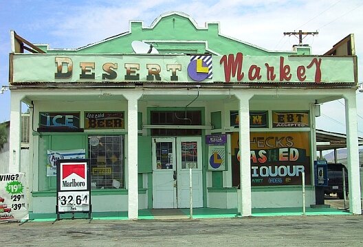 The Desert Market in Daggett is on the other side of the only railroad tracks to hold us up on the
entire trip. We'd been seeing a lot of long trains ever since New Mexico (and hearing them
most of the night behind our wigwam) but had been lucky thus far at crossings. But it's a nice photo op.
The Desert Market in Daggett is on the other side of the only railroad tracks to hold us up on the
entire trip. We'd been seeing a lot of long trains ever since New Mexico (and hearing them
most of the night behind our wigwam) but had been lucky thus far at crossings. But it's a nice photo op.
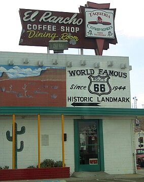 Lunch was at the El Rancho Coffee Shop and Dining Room in Barstow, where the winner was a Pork Torta
(sort of a Mexican sub on a soft bun - very tasty). Unfortunately the "museum" was no longer open.
Lunch was at the El Rancho Coffee Shop and Dining Room in Barstow, where the winner was a Pork Torta
(sort of a Mexican sub on a soft bun - very tasty). Unfortunately the "museum" was no longer open.
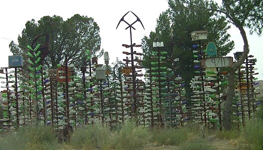 There was some more folk art on the Route that we couldn't pass up, between Barstow and Victorville.
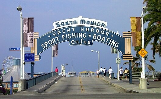 And so the next morning we found the end of the Route at the Santa Monica Pier.
Over the last few years I have received many comments and inquiries from readers of this page, and the most common
question is "how long did you take to make the trip?" By way of answering, I thought I'd add a brief chronology of the
places where we stopped for the night: